

Many would agree that Arkansas isn't the first place in the United States where people would want to visit. In fact, it is not a surprise that it's not included in the to-go list of various tourists and travelers. Despite this, no one can downplay the fact that Arkansas is a beautiful place. It is studded with beaches, hot springs, and swimming holes.
At the same time, the state is also the home of exceptional hiking spots, which include trails in the Ozark Mountains. Hiking in Arkansas is best done during fall. If you hike in the summer, it would be too hot and humid. Many areas are great for beginners. But if you are proud of your hiking skills already, I suggest that you try them in Eagle Rock Loop.
In this post, I've listed some of the finest places you can hike in Arkansas. For hike-thirsty individuals, these hiking trails are the best gems that the Natural State can offer.
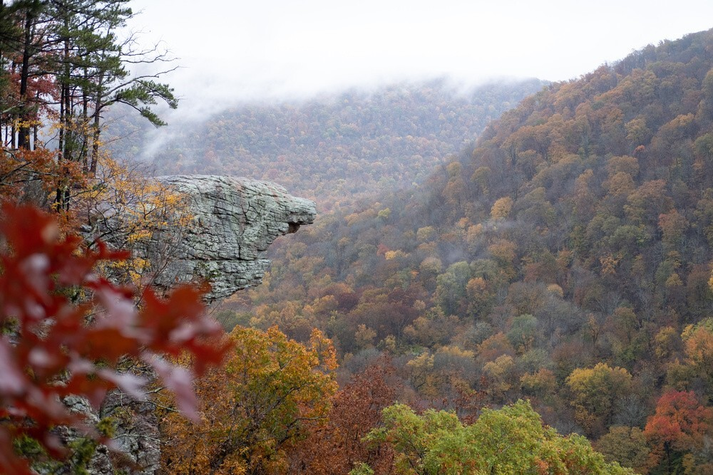
You can find the Hawksbill Crag in the heart of the Ozark National Forest. It is considered a hiking treasure in the state. In fact, it is so well-known that the area is heavily trafficked by hikers all year long. To get to this destination, one should ascend first the Whitaker Point Trail.
The entire trail is roughly 4.7-kilometer long and can be traversed for two hours or more. It can take you on an exotic trip--deep inside a forested trail. While on the route, you'll spot scattered falls along the way. After you get out of the trail, you will be welcomed by an open crag that features superb rock formation. Specifically, the crag protrudes from the cliff, which causes it to resemble a beak.

In Arkansas, the longest backpacking loop that you can trek is the Eagle Rock Loop. As I mentioned earlier, this one is probably the most difficult hiking route throughout the state. However, it remains to be popular among hikers and serious outdoor enthusiasts.
It would take a regular hiker to finish this trail for three days, so you can imagine the degree of challenge that this route provides. This 42.6-kilometer trail is actually the amalgamation of the Athens-Big Fork Trail, Little Missouri Trail, and certain portions of the Viles Branch Horse Trail.
The Eagle Rock Loop has numerous access points, which is quite advantageous if you want to try something new from time to time. You also have the option to complete this loop either counterclockwise or clockwise. One of the famous starting points is the Winding Stairs Trailhead.
One of the most notable features of the Eagle Rock Loop is the number of water bodies that you can encounter while traversing its entirety. Moreover, it also provides a lot of designated faces where you can camp and spend the night. Also, let me remind you that the creeks that you'll pass here have varying depths. If it is rainy, some of them are dangerous to pass through.
Despite these ordeals, many are still attracted to go on this trail. After all, it represents the quintessential wilderness of Arkansas. It features a wide array of waterfalls, rivers, tree groves, and exuberant vegetation.

If you are looking for a short yet plentiful hike, then the Lost Valley Trail is an exceptional choice for you. This one will lead you to the majestic Clark Creek; it will also let you course through numerous natural bridges until such time you reach Cobb Cave and Eden Falls.
Since the hike is generally short, you have more time to rest or explore the rock formations and caves along the area. The trail will also let you experience traversing through crushed stones and smooth, natural pavements. Keep in mind that the most alluring part of the trail will require you to pour a lot of sweat. But keep in mind that it is indeed worth it.
Of course, I also recommend preparing for some water trekking in the creek. It is one of the highlights of the hike. Many locals go there on the weekend to find solitude.
While on the Lost Valley Trail, you have the opportunity to reach the Natural Bridge. The latter is a limestone tunnel that runs with an overall length of 50 feet.

The Centerpoint to Goat Trail is an exceptional hiking trail in Arkansas. This one is an out-and-back trail and is situated within the proximity of Ponca. You may not need to be an expert hiker to traverse this route. However, you have at least some experience, as it is rated as a moderate hiking trail.
This 9.5-kilometer escapade has commonly been trekked for various reasons. It is not only suitable for hiking, but it is also a wonderful spot for fishing, camping, and ultralight backpacking.
It's not surprising that the Centerpoint to Goat Trail is touted as one of the frequently taken routes in the Buffalo National River premise. In fact, during regular days, the Centerpoint Trailhead's parking lot can get full quickly. Tourists and hikers are eager to reach the Big Bluff, which serves as the vantage point to the Buffalo River, which has an elevation of 500 feet tall. Meanwhile, its side trail is called the Goat Trail and has a height of up to 350 feet. If you have a fear of heights, this hike is not for you.

One of the most strenuous day hikes you can experience in Arkansas is the Pinnacle Mountain West Summit Trail. It is a rocky trail that has an overall length of at least 2.4 kilometers. Specifically, it is an out-and-back trail situated in the proximity of Little Rock.
This hike is nothing short of challenging. Even experienced hikers said that the trail itself is difficult, despite it being a relatively short hike.
You can start your journey on this trail by proceeding to the picnic grounds of the Pinnacle Mountain State Park. On your way, you will have to ascend so that you can reach the summit of Pinnacle Mountain. Along the way, you'll be greeted by the lush wildflowers sprawling in the area.
Once on top, your efforts will be rewarded. There, you'll have a panoramic view of some of the most beautiful scenery in Arkansas, such as West Little Rock, Lake Maumelle, and the Arkansas River Valley.
You have the option to descend to East Summit Trail if you want to return to the ground. However, keep in mind that it is also a rugged trail.
The Yellow Rock Trail is one of the historic and oldest trails that exist within Arkansas. The trail itself has been a CCC-constructed outdoor route during the 1930s. It is also included in the National Trails System.
This 5-kilometer hiking route has moderate difficulty, so average hikers have the opportunity to complete it. One of its notable spectacles is the Yellow Rock Overlook. The latter provides a glorious view over the stunning Lee Creek Valley. On normal days, the trail can get crowded. I suggest that you avoid hiking here during weekends.
The maximum elevation of the Yellow Rock Trail is roughly 300 feet, so there's always something to see around you. The trail is also studded with amazing rock formations. Even the path itself is mostly rocky. Hence, hiking poles are always required equipment here. Moreover, the trail is also dog- and horse-friendly.
Interestingly, there are two trailheads of the Yellow Rock Trail: the Camp Area A trailhead and the Highway 700 CCC.

If you want to have an excellent view of the tallest waterfall throughout middle America, then I recommend that you check out the Hemmed-In Hollow Trail. This trail is accessible from Highway 43, which is south of Compton. Meanwhile, its trailhead is adjacent to the Erbie Road and features a properly signed route that will lead you to the Buffalo National River Wilderness Area.
The Hollow Falls, which is squeezed between the Appalachians to the east and the Rocky Mountains to the west, is definitely a spot worth seeing here. Despite its enormous length, its water volume isn't as grand as other falls. However, the unique geology that surrounds this water body makes the journey worthwhile.
Essentially, this hike is rated difficult by many hikers, especially if you pass through the regular route. However, there's another less exhausting alternative here. You can reach the Hemmed-In Hollow by cruising through the upper portion of Buffalo River when it is canoeing season. You will start your journey in feet in the Jim Bluff downstream. After that, you will just have to do moderate hikes for at least an hour before you can reach the destination.

The Glory Hole Falls is considered one of the fascinating waterfalls throughout the Ozark National Forest. Specifically, the falls are created by a gentle stream that ebbs through the roof of an overhanging cave. Every time that the water is fully flowing, it adds to the spectacular wonders that you can see while you are hiking on this trail.
Specifically, the Glory Hole Waterfall Trail is situated in the Newton County, Big Piney District. It is a well-maintained path, with most of it will require you to trudge along old roads used by jeeps. However, keep in mind that there's no designated official trailhead or parking area for this trail.
The "unofficial trailhead is situated adjacent to Highway 16, which is around 6 miles to the eastern portion of Fallsville.